That statement means nothing to this post other than the fact that if you put him on a dirt road, he is looking at everything other than where he his driving. I can remember as a kid riding shotgun with the windows down and my Dad looking for animals. We never drove off the road, but I had some moments along the way where I wondered if we were going to make it.. No wonder I have no hair now. I could continue to whine about my Father's driving but I am definitely my Father's son. I'm actually worse, because I do the same thing, only on pavement and I am looking for trails.
Can you imagine the conversation with the Police? "I know officer, but do you see that trail running up the side of the hill over there...what do you think the elevation gain is on that? That's got to be zone 4 the whole way up for sure!"
Yeah, not good.
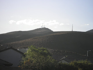
Coach Cyndee had hills on the training agenda today and so I thought that Arden Peak would be a good one to try.
 |
| Arden Peak. Black Mountain is just out of the picture to the right. |
The homes in Anthem have been built right up to the base of Black Mountain. As Vegas (along with communities across the country) try and improve their recreational trail systems, more money has been spent on their development. The Anthem East Trail is a part of this development.
Traveling 7.5 miles of the foothills behind Anthem, this trail has can be pretty tough and has zero shade. I have run it from both sides and that is how I came across the Radio Towers on Arden Peak.
 |
| The Shadow Canyon Trailhead for the Anthem East Trail. |
The trail is paved on both ends and there are restrooms at the Anthem Hills Park side trailhead. Dirt road and singletrack in the middle portion. The trail is not very technical but it does have some very steep sections and a lot of switchbacks.
 |
| Anthem East Trail moves left over the hill. The Arden Peak access road moves to the right. |
The trail to Arden Peak is basically uphill the entire way with you starting on the Anthem East Trail. From the Shadow Canyon trailhead, the paved portion takes you to a flood control collection area. If you take the singletrack to the right of the flood control basin it will take you to the Black Mountain Trailhead. Left and across the small dam in the front of the collection area keeps you on Anthem East. Keep going straight onto the dirt and broken gravel road and this will take you up to the fork in the trail that is pictured above. Left keeps you on Anthem East and right will take you to the radio towers.
I was feeling a little slow, chugging my way up the hill, but the view is more than worth it.
 |
| Looking back at the Las Vegas valley. |
The radio towers seem closer than what they actually are. The service road that you work your way up constantly works its way around the sight line, so you think you are almost there and then you clear the hill and realize that you still have a ways to go. The grade is fairly consistent the entire way. I have to say that all the flat speed work that I have done lately has not been helping my mountain climbing ability.
Before you can get all the way to the last set of towers, the road is gated and access is restricted. I had visions of men in dark sunglasses and black suits. Maybe a dog with bad teeth that talks would be thrown in as a sidekick...
 |
| End of the line just short of the third set of radio towers. |
 |
| The middle tower at the turnaround. |
There is a fair amount of foot traffic on the lower portion of the trail but people are courteous and the trail is wide in these areas. Overall, I'm going to have to give it 3 stars. Trail profile in the Garmin link below.
1:12:15/5.63 miles
Garmin Details


This run started at 10am and it got up to 82f. I nailed my nutrition and water on this 10 mile run with 2100 feet of elevation gain. The trick for me is to get enough sleep befor a big money work out like this. Best of all I got Jeff to join me the rock out this run. For some reason out on this run I felt like an ultramarathon runner? Thanks Jeff
ReplyDelete